
China is accused of collecting and sharing satellite imagery with Iran to target civilian infrastructure in the Central Region and U.S. military assets in the Arabian Gulf.
Beijing denies it, but experts quoted by Al Jazeera news say an increase in the accuracy of Iranian targeting since Operation Epic Fury began on February 28 suggests Chinese input is enabling the Iranian weapons’ effectiveness. Associated social media channels have published detailed information on U.S. military forces and aircraft massing in Israel, Qatar and Saudi Arabia, likely improving adversary awareness.
Chinese satellite imagery of the conflict zone has proliferated since the start of Operation Epic Fury, The Wall Street Journal newspaper reported. This includes claims on social media by Chinese artificial intelligence company MizarVision that it has used AI to analyze satellite data and track movements of U.S. forces and equipment.
U.S. politicians have also warned that Iranian forces may be relying on commercial satellite data from several sources, the Journal reported. Using commercial data potentially provides plausible deniability.
The rise of commercial satellite imagery has opened to public view the kind of battlefield information once closely held by sovereign military and intelligence interests. In April, California-based Planet Labs, a leader in the field, stopped supplying imagery to the public from Middle East conflict zones after the U.S. military expressed concern it could provide adversaries with “tactical leverage.” Chinese satellite companies operate under no such limitations.
In addition, the U.S.-China Economic and Security Review Commission, an advisor to the U.S. Congress, reported in March that Iran may be using its access to the Chinese Communist Party’s BeiDou satellite navigation system to direct drone and missile strikes across the Middle East. BeiDou is the Chinese version of the U.S.-operated GPS.
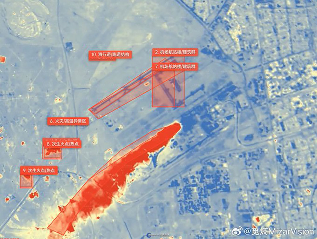
X@MIZARVISION
Arabian Gulf states have called the Iranian drone and missile attacks a serious violation of their sovereignty. To coordinate a response to these unprecedented attacks, leaders of Gulf Cooperation Council held a summit in Jeddah, Saudi Arabia, on April 28.
They “underlined the importance of intensifying military integration among the member states and accelerating the completion of the early warning system project against ballistic missiles, GCC Secretary-General Jasem Al Budaiwi said.
As of August 2024, Chinese commercial satellite companies were participating in business exchanges with Iran’s Islamic Revolutionary Guard Corps, according to the 2025 Annual Report to Congress from the U.S. Department of War.
Suspicions about Chinese support for Iran comes as U.S. intelligence agencies are seeing signs that Russia has provided the Iranian military with satellite intelligence to help target the U.S. and its partners.
China is the main buyer of Iran’s oil and the nation’s No. 1 trading partner. It has used its leverage to urge Iran back to the negotiating table to bring an end to the ongoing conflict, The Associated Press reported. Nevertheless, the Iranian ballistic missile program that executed hundreds of launches across the Middle East in the early days of Operation Epic Fury was built with Chinese technology, the U.S. government has said.
Eliminating or diminishing the ballistic missile program was among the objectives of Operation Epic Fury. A U.S. news release on April 8 said more than 85% of Iran’s defense industrial base, including most ballistic missiles, launcher vehicles and long-range attack drones, had been destroyed. In a list of damage inflicted during the early days of the operation, the news release also said, “Iran’s once-vaunted space program has been devastated. Seventy percent of its launch facilities and ground control stations have been destroyed or degraded, preventing the regime from using space for military purposes.”
Overall, China’s military relationship with Iran has been focused on an annual trilateral naval exercise with Russia, limited bilateral military training and China-based companies’ sale of dual-use components for Iran’s ballistic missile and drone programs, according to the report to the U.S. Congress. Defense ministers from the two nations conduct reciprocal visits almost every two years, but Beijing probably is reluctant to deepen the modest defense relationship “for fear of diplomatic blowback and sanctions,” the report said.